Polk County GIS offers a comprehensive platform for interactive parcel maps, land records, and property boundaries across central Iowa. Residents, real estate professionals, and developers can examine detailed property layers, overlay geographic features, and review official ownership records directly through the county’s digital mapping system. The platform integrates zoning data, land use patterns, and public infrastructure information, making it a central resource for informed decisions and property management. By providing official and precise geographic data, Polk County GIS supports accurate planning and analysis for both public and private projects.
The system includes tools for measuring parcels, analyzing property dimensions, and tracking historical land changes. Users can visualize roads, waterways, and neighborhood layouts alongside property information, enhancing transparency and accessibility. With GIS mapping technology, Polk County ensures that land records remain accurate, up-to-date, and easy to explore. Professionals can evaluate trends in property values, identify development opportunities, and assess potential zoning changes with confidence. By combining parcel-level details with a user-friendly interface, the GIS hub serves as a trusted source for geographic insights across the county.
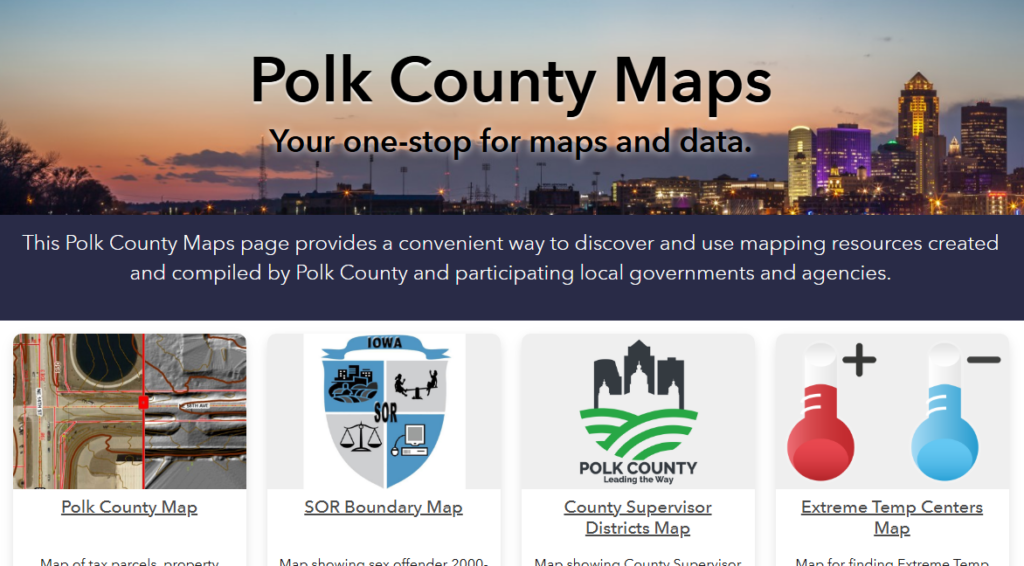
Start With the Polk County GIS Hub
The Polk County GIS Hub is the central online platform for accessing a wide range of geographic data for the county. It provides residents, planners, and researchers with interactive maps, parcel information, and official county datasets.
The GIS hub offers an organized GIS catalog where users can explore multiple map layers, including property parcels, zoning boundaries, transportation networks, and aerial imagery. Anyone can access the hub directly through the Polk County government website, which hosts the GIS hub Polk County portal. Registration is optional, but creating an account allows users to save maps and set personalized preferences.
Types of Data and Interactive Maps
The hub organizes data into clear categories for easy use:
- https://maps.polkcountyiowa.gov/portal/apps/sites/#/gis-maps/
- Parcel Maps: Detailed property boundaries, owner information, and assessed values.
- County Boundaries: City limits, school districts, voting precincts, and municipal zones.
- Aerial Imagery: High-resolution overhead views updated regularly for planning and analysis.
- Transportation & Infrastructure: Roads, highways, rail lines, utilities, and public facilities.
Each map layer is interactive. Users can click features to see detailed information and toggle layers on or off for customized views. The GIS hub also supports search and tagging tools that let users locate parcels or specific geographic features quickly.
Government Disclaimers and Legal Notes
All datasets include clear government disclaimers. The county notes that maps are for informational purposes and should not replace legal surveys or official property records. Users are encouraged to reference official documents when making legal or financial decisions. The hub also includes guidance on data use, emphasizing that the maps reflect the most current information available but may not be error-free. For professionals, it provides links to official GIS services and contact information for technical questions.
With its interactive maps, county datasets, and searchable GIS catalog, the Polk County GIS Hub is a reliable resource for anyone needing geographic information in the area. Its user-friendly interface makes it straightforward to explore land records, analyze property data, and view government-provided maps efficiently.
Navigating the Interactive County Map
The Polk County GIS Hub makes exploring land and property information simple and intuitive. Users can quickly view parcels, addresses, and administrative boundaries with just a few clicks.
The interactive county map serves as a central tool for residents, developers, and professionals seeking detailed geographic and property data. With the parcel viewer Polk County feature, users can search properties using owner names, parcel IDs, or addresses. This search functionality ensures that anyone can pinpoint exact property locations or review property details efficiently. For instance, entering a parcel ID instantly highlights the property on the map, showing its boundaries, nearby roads, and adjacent parcels.
Search Parcels and Addresses
Users can search parcels and addresses by:
- Owner Name: Locate properties owned by specific individuals or businesses.
- Address: Pinpoint properties within subdivisions, streets, or neighborhoods.
- Parcel ID: Access detailed property information quickly.
This search system integrates tax parcels, subdivision lookup, and administrative boundaries, enabling accurate retrieval of data. It’s particularly useful for real estate research, tax assessments, and planning projects.
Toggle Map Layers
The map allows toggling multiple map layers for a customized view:
- Tax Parcels: Display official county property lines.
- Roads and Highways: Identify local and major roads.
- Political Boundaries: See city limits, school districts, and voting precincts.
- Environmental Layers: Include flood zones, wetlands, and parks.
Users can combine layers to compare property details with local zoning or environmental data. This visual approach improves decision-making for developers, surveyors, and homeowners.
Review Zoning and Land Use
The GIS map includes zoning and land-use information for unincorporated areas. Users can:
- Examine zoning classifications for residential, commercial, or industrial uses.
- Check land-use policies for development restrictions or permitted activities.
This feature helps property owners and investors understand what types of projects or improvements are allowed in specific areas. Displaying these layers alongside parcel boundaries provides a clear perspective of county regulations.
Examine Elevation & Terrain
Advanced GIS tools let users study elevation and terrain features:
- Contours and Slope Data: Identify land elevation changes.
- LiDAR Hillshade: View detailed surface models for precise analysis.
- Drainage Evaluation: Assess flood risk and water flow patterns.
These features are essential for construction planning, environmental studies, and infrastructure development. Combined with parcel and zoning layers, they offer a complete picture of a property’s physical and regulatory environment.
Leveraging the Auditor’s Real Estate Atlas
The Auditor’s Real Estate Atlas in Polk County provides detailed https://atlas.polkcountyiowa.gov/?map=OwnersAddresses parcel maps that help residents, investors, and professionals explore property boundaries, ownership history, and land use. Users can quickly locate parcels using an address, owner name, or parcel number.
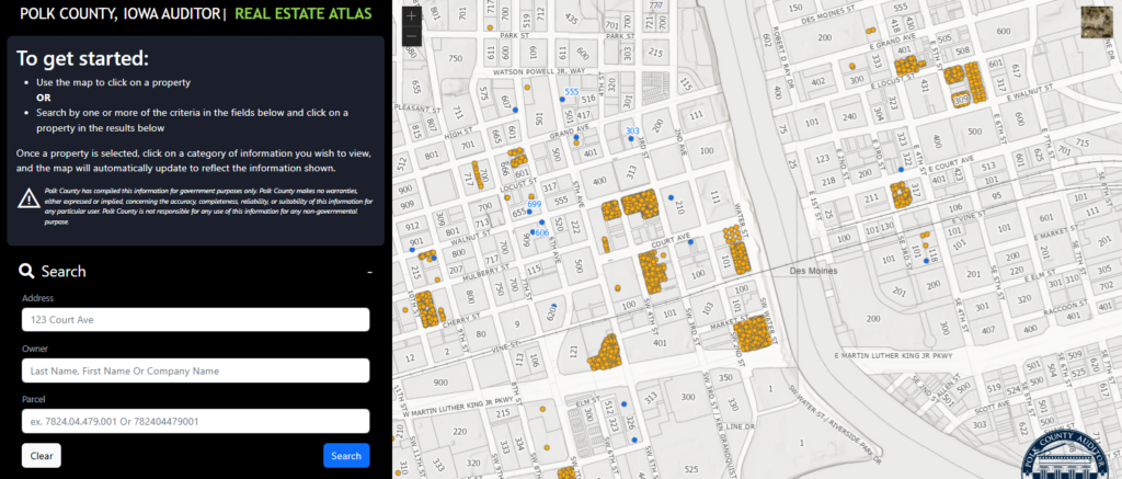
Efficient Search Workflow
The Atlas offers multiple search options for precise results:
- Address Search: Enter a street address to view property lines and parcel information.
- Owner Search: Look up parcels by owner name to check multiple holdings.
- Parcel Number Search: Use the unique parcel ID for exact property identification.
This search flexibility simplifies property research and helps users quickly pinpoint relevant parcels within Polk County.
Viewing Parcel-Level Data and Valuation
Once a parcel is selected, the Atlas displays comprehensive data, including:
- Parcel Boundaries: Clear maps showing property lines and neighboring plots.
- Valuation Info: Current assessed value and historical trends for taxation purposes.
- Subdivision Context: Details about lot dimensions, zoning, and nearby infrastructure.
These features make the Atlas a practical tool for real estate analysis, investment evaluation, and property comparisons.
Connecting Atlas Data to Assessor & Recorder Systems
The Auditor’s Atlas integrates seamlessly with other county systems:
- Assessor Data: Cross-reference ownership records, assessed values, and tax history.
- Recorder Records: Access deed information, easements, and official property documents.
By linking these sources, users gain a holistic view of each property, making research more precise and time-efficient.
Parcel and Boundary Layers That Drive Decisions
Parcel and boundary layers in Polk County GIS provide precise property outlines and legal divisions critical for planning, development, and public services. These layers give users a clear view of land ownership, political districts, and zoning regulations.
Parcels & Cadastral Context: Legal Boundaries, Historical Parcels
Polk County GIS parcel maps display detailed property boundaries and cadastral information, showing the exact lines of ownership. Each parcel includes historical data, ownership details, and legal descriptions, often tied to the section-township-range system used in land surveys. This helps local governments, surveyors, and developers track property changes and manage records accurately.
- Cadastral maps highlight property lines and subdivisions.
- Historical parcels reveal past ownership and land transfers.
- Legal descriptions ensure clarity for deeds, titles, and transactions.
These parcel layers assist in decisions ranging from property purchases to public infrastructure projects. The historical context can also show patterns in land development and conservation areas.
Political & Administrative Boundaries: Township, Drainage, Fire, School Districts
Polk County GIS includes political and administrative layers that define townships, drainage districts, fire districts, school boundaries, and corporate limits. These boundaries guide service delivery, emergency planning, and taxation.
- Township boundaries define local governance areas.
- Fire and emergency districts ensure proper coverage.
- School districts’ impact planning for enrollment and transportation.
- Drainage and utility districts are essential for infrastructure management.
Layering political and administrative boundaries over parcel maps allows officials and residents to visualize jurisdictional responsibilities and evaluate land-use conflicts or overlaps.
Zoning & Land Use: Regulatory Land-Use, Setbacks, Long-Range Planning
Zoning and land-use layers in Polk County GIS indicate how parcels can be developed, showing permitted uses, setbacks, and density restrictions. These layers help city planners, developers, and property owners make informed choices that comply with regulations.
- Zoning maps highlight commercial, residential, and industrial areas.
- TIF districts identify regions with tax incentives for development.
- Long-range planning layers assist with future growth and infrastructure projects.
By combining parcel data, political boundaries, and zoning information, Polk County GIS provides a comprehensive framework for decision-making, ensuring that property management, development, and public planning are data-driven and accurate.
Elevation, Hydrology, and Environmental Constraints
Polk County GIS provides detailed elevation and hydrology data that helps planners, engineers, and property owners make informed decisions. The GIS layers Polk County offers include contour maps, FEMA flood zones, wetlands, and other environmental constraints critical for development and land management.
Contours & LiDAR for Grading and Drainage
Contour maps and LiDAR surfaces are essential GIS layers that Polk County offers for analyzing terrain. Contour intervals show changes in elevation, making it easier to plan drainage, grading, and construction projects. LiDAR data provides highly accurate 3D elevation surfaces that can identify slopes, depressions, and ridges. Users can:
- Assess property for potential flooding or erosion
- Plan site grading efficiently
- Evaluate slope stability for construction projects
These GIS layers that Polk County supports help reduce risks and improve project outcomes by providing precise landform data.
FEMA NFHL and Base Flood Elevation Layers
Flood risk assessment is simplified with the FEMA National Flood Hazard Layer (NFHL). This layer shows floodplains, special flood hazard areas, and base flood elevations (BFEs). By combining FEMA NFHL with local elevation data, property owners and planners can:
- Determine flood insurance requirements
- Identify high-risk areas before building
- Support regulatory compliance for permits
The integration of FEMA NFHL with Polk County GIS layers ensures users have a clear picture of hydrologic hazards.
National Wetlands Inventory Layers
Polk County GIS also includes the National Wetlands Inventory (NWI) layers. These identify wetland locations, types, and boundaries, which are crucial for environmental assessments.
Wetland mapping helps:
- Avoid construction in protected areas
- Plan mitigation strategies for unavoidable impacts
- Support compliance with state and federal regulations
Wetlands GIS layers, combined with elevation and hydrology data, provide a complete environmental overview for decision-making.
Historical and Aerial Imagery for Insight
Polk County provides detailed aerial imagery and historic GIS maps that help track land changes over decades. These resources allow property owners, planners, and researchers to observe how landscapes and developments have evolved.
Recent Annual Aerials: 2017–2025
The county maintains high-resolution aerial imagery captured annually from 2017 through 2025. These images provide accurate views of current land use, roads, and building footprints. Users can:
- Compare property boundaries year by year
- Identify subdivision build-out trends
- Examine changes in vegetation, water features, and infrastructure
For example, property researchers can trace how a residential area expanded between 2018 and 2023, while developers can assess vacant land for potential projects. The annual imagery also supports compliance monitoring, such as verifying zoning or construction permits.
Historic Imagery: 1930s Onward
Polk County’s historic imagery archives stretch back to the 1930s, offering a time-series perspective on land-cover change. These maps reveal past farmland patterns, early urban layouts, and evolving transportation networks. Key benefits include:
- Studying long-term land-cover change
- Identifying older structures or previous property boundaries
- Supporting legal or historical research for land ownership disputes
By overlaying historic maps with modern aerial imagery, users can see how neighborhoods, farmland, and natural areas transformed over nearly a century.
Integrating GIS With County Systems
Polk County GIS connects critical county systems, making land records, assessments, and planning data more accessible and accurate. By linking parcel IDs with county departments, officials and residents can work efficiently with property and development information.
Linking GIS Parcel IDs to Assessor Valuations
Each property in Polk County is assigned a unique parcel ID, which the GIS system ties directly to the Assessor’s valuation data. This allows users to see current property values, tax information, and historical assessments in a single view. County staff rely on this integration to:
- Quickly verify property ownership and valuation.
- Track changes in land use and property improvements.
- Support fair taxation based on accurate parcel data.
By connecting GIS data with the Assessor’s records, Polk County ensures that property information is consistent and reliable for public and internal use.
Recorder Connections for Deeds and Plats
The GIS system also links parcel maps to the Recorder’s office. This integration provides immediate access to deeds, plats, and legal documents associated with each property. Residents and professionals can:
- View property deed histories and recorded plats.
- Confirm lot boundaries and easements.
- Reduce errors when filing legal or tax documents.
These connections strengthen transparency and help streamline workflows for both the public and county staff.
Planning and Development Coordination
GIS data supports county planning and public works projects by combining parcel information with zoning, land use, and infrastructure data. Planners and developers can:
- Identify suitable locations for new construction or redevelopment.
- Coordinate road, utility, and public works projects with property boundaries.
- Evaluate environmental or zoning constraints for proposed projects.
By integrating GIS with land records, Polk County departments can make informed decisions, enhance efficiency, and improve overall service to residents. This system ensures that property, planning, and development data work together seamlessly.
GIS Hub Search, Tagging, and Data Use
The Polk County GIS Hub allows users to quickly find, filter, and use geographic data for parcels, boundaries, and aerial imagery. Its tools support tagging, metadata management, and advanced data workflows for government and enterprise applications.
The GIS Hub in Polk County provides an organized platform where users can search and explore geographic information system (GIS) data efficiently. Users can apply filters for parcels, property boundaries, zoning layers, and aerial imagery, making it easier to locate specific maps or datasets. Search features include keyword queries, category selection, and metadata tags, which help classify data by type, source, or update date.
Using Filters for Parcels, Boundaries, and Aerials
The Hub offers interactive filters to refine results:
- Parcel filters: Identify properties by owner, assessment value, or land use.
- Boundary layers: Focus on city limits, school districts, or election precincts.
- Aerial imagery: Sort by year, resolution, or image type.
These tools allow both casual users and professionals to access precise information without sifting through unrelated data. For instance, local planners and developers can isolate parcels that match zoning requirements while government staff can monitor infrastructure changes.
Data Disclaimers, Government Use, and Availability
All datasets on the GIS Hub include clear metadata and disclaimers. Data accuracy depends on regular updates from the Polk County Assessor, Surveyor, and other departments. While most GIS data is publicly available, some layers may have restricted access for government or enterprise use. Users are encouraged to check licensing notes and data provenance before integrating information into official projects.
Enterprise Workflows via GIS REST Services
Advanced users can connect to Polk County’s GIS REST Services to automate workflows and integrate data into mapping software or enterprise applications.
REST endpoints provide access to:
- Parcel and boundary layers in real-time
- Dynamic aerial imagery feeds
- Custom queries using filters and metadata tags
These services support planning, reporting, and analysis, enabling professionals to work with GIS data programmatically while maintaining consistent updates. By combining tagging, category search, and REST access, the GIS Hub offers a reliable foundation for informed decisions across public and private sectors.
Zoning, Land Use, and Environmental Due Diligence
Polk County zoning maps and land-use GIS data help property owners and developers confirm permitted uses and assess environmental considerations quickly. These resources provide a clear view of zoning boundaries, flood layers, wetlands, and other environmental factors for informed decision-making.
Property evaluation in Polk County begins with zoning verification. Zoning maps that Polk County provides show permitted land uses for unincorporated areas, including residential, commercial, agricultural, and industrial classifications. Property owners can check if a proposed project aligns with local zoning regulations. GIS-based land-use data allows users to overlay parcel maps with flood layers, wetlands, and hydro layers, helping identify restrictions or potential risks before development.
Environmental and Regulatory Screening
Environmental due diligence is a key step for any land transaction or project. Polk County GIS tools enable users to review:
- Flood risk zones for drainage and construction planning
- Wetlands and protected areas that may require permits
- Hydro layers showing water features that affect site access and grading
- Soil types and slope data for construction suitability
Screening these factors early reduces delays and ensures compliance with county and state regulations. It also helps property owners anticipate costs related to permits or environmental mitigation.
Coordinate with Public Works for Official Interpretation
While GIS maps and land-use layers provide reliable guidance, official interpretation is available through Polk County Public Works. Contacting the department can clarify zoning disputes, confirm permit requirements, or resolve boundary issues. Their staff can verify findings, provide legal interpretations, and recommend the proper steps for site evaluation.
For using Polk County GIS for due diligence:
- Start with the zoning maps to confirm permitted uses.
- Overlay environmental layers to check for wetlands, flood areas, or hydro constraints.
- Consult Public Works for final verification before purchasing or developing land.
Using these resources together ensures property decisions are informed by accurate data, reducing risk and improving project planning.
Enterprise Portal and Advanced GIS Tools
The GIS Enterprise Portal of Polk County provides a centralized platform for organizations to access spatial data and GIS services efficiently. It allows teams to interact with maps, layers, and web services in a secure, organized environment.
Organization-Wide Resource Access
The Enterprise Portal acts as a hub for all GIS resources across Polk County departments. Employees, planners, and developers can view official maps, analyze land parcels, and track infrastructure data. Features include:
- Role-based access to sensitive GIS layers
- Shared maps and dashboards for collaboration
- Customizable workspaces for different departments
This system ensures that county teams work with consistent, up-to-date geographic information, improving decision-making and planning projects more accurately.
Machine-Readable Endpoints
Polk County’s GIS portal provides REST API endpoints that allow applications to interact directly with GIS data. These endpoints are designed for developers and analysts who need:
- Automated data queries for land records or zoning maps
- Integration with third-party software like GIS desktop apps
- Programmatic access for reporting and analytics
Machine-readable services ensure that GIS information is flexible and usable in multiple formats, reducing manual work for data processing.
Exporting and Integrating Official GIS Layers
Users can export official GIS layers in formats such as Shapefile, GeoJSON, and KML, making it easier to integrate with external GIS tools or enterprise systems. Benefits include:
- Seamless integration with planning and mapping software
- High-quality, official data for accurate analysis
- Support for both visual maps and analytical workflows
The portal also supports scheduling automated updates, ensuring that exported layers reflect the most recent land and parcel changes in Polk County. This combination of tools positions the GIS Enterprise Portal as a practical and efficient solution for government, developers, and GIS professionals seeking reliable spatial data access.
Polk County GIS FAQs
Polk County GIS provides residents and professionals with official parcel and land data through an interactive map. Users can quickly view property boundaries, zoning, land use, and flood layers. The parcel viewer for Polk County allows searching by address, owner, or parcel ID. Official datasets come directly from the Assessor and Recorder offices. These tools support property research, planning, and municipal projects. Accessing the GIS Hub ensures reliable and up-to-date spatial information.
Accessing Official GIS Maps and Datasets
Residents can access all Polk County GIS maps and datasets via the Polk County GIS Hub, which offers detailed parcel boundaries, streets, and public infrastructure. The interactive platform allows toggling map layers for zoning, land use, and flood zones. Users can also download datasets for analysis or professional planning. The Hub ensures data accuracy by integrating records from official Assessor and Recorder sources. Maps can be printed or exported for project documentation or personal reference.
Searching Parcels and Addresses
The parcel viewer for Polk County makes it easy to locate property details quickly. Users can search by parcel number, street address, or owner name and click on map parcels for more information. Pop-ups display details such as lot size, assessed value, and property type. Maps can be exported or printed for personal or professional use. These search features simplify tasks for homeowners, developers, and real estate professionals alike.
Layers: Zoning, Land Use, and Flood Data
Polk County GIS provides multiple map layers to evaluate property and land conditions. Zoning layers show whether areas are residential, commercial, or industrial. Land use layers display how properties are currently utilized. Flood layers highlight risk areas using FEMA data. Users can toggle layers to see overlapping information, which helps with property evaluation and planning decisions. Layer guidance ensures users interpret GIS data correctly for compliance or project purposes.
Integrating GIS Data with Assessor and Recorder Records
GIS maps can be combined with Assessor and Recorder records for a complete property overview. Users can verify ownership history, review assessed values, and confirm zoning compliance. This integration allows cross-referencing parcel boundaries with legal documents. It supports developers, real estate agents, and homeowners in research or planning. Interactive maps and official records together provide actionable insights for any property-related project.
Exporting and Using GIS Data?
Users can export Polk County GIS data for personal, professional, or planning purposes directly from the interactive map. The platform allows downloading parcel boundaries, zoning, and land use layers in formats like CSV, shapefile, or PDF. Exported data can be integrated with other tools for analysis or mapping projects. Instructions and guidance are provided on the GIS Hub to ensure proper use. This feature helps residents, developers, and government staff make informed decisions using official spatial data.